Archives
Enter a word or phrase to perform a general search across all records in the Archives catalog. You can also browse records in the catalog without performing a search.
Search Tips
- Searches are not case sensitive.
- Searching for multiple words connects them with OR by default. Matching records can contain any of the words.
- Connect multiple words with AND if you only want to see records containing both words.
- Use quotation marks to search for a phrase.
- Place an asterisk (*) at the end of a word as a wildcard.
1187 results found. Records searched: 1187
-
Timaru Harbour Board : plan shewing the port limits of Timaru being a line two and a half miles radius from the first monolith of the breakwater - Timaru Harbour Board
Blueprint plan of the Timaru Harbour port limits (a line two and a half miles radius from the first monolith of the breakwater). Signed by the Timaru Harbour Board Engineer John Goodall, dated 14 February 1883. Also bears an illegible signature that appears to indicate that the pilotage district was the same in 1889. Timaru Harbour Board plan no.1066
Record Type: Archive

-
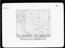
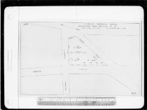
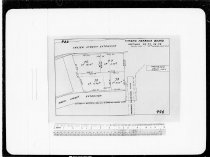
Timaru Harbour Board : plan showing Dawson Street area - Timaru Harbour Board
Timaru Harbour Board plan showing the Dawson Street area. Originally drawn March 1960, with additions and deletions in 1962 and 1965. Shows lots, drain, water, sewage, and oil lines on Dawson Street, and the area intersecting with Ritchie Street. Also shows existing tenants including: Vacuum Oil Co, SC Co-op Cool Stores, GE Tregenza, Shell Oil, and the NZ Electricity Department. Timaru Harbour Board plan no.1070A
Record Type: Archive

-
Timaru Harbour Board : plan showing construction of jetty and structure to take building for Timaru Fish Co.Ltd - Timaru Harbour Board
Timaru Harbour Board plan showing construction of jetty and structure to take building for Timaru Fish Co.Ltd, dated 29 March 1957. Provides two sections and a plan of the jetty. Stamped "Approved Pursuant to the Harbour Act 1950" and signed by Minister of Marine on 15 May 1957. Timaru Harbour Board plan no.1005. Stamped "Copy of M.D.10192"
Record Type: Archive

-
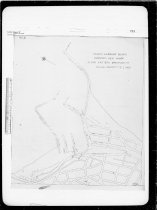
Timaru Harbour Board : plan showing foreshore - Timaru Harbour Board
Timaru Harbour Board plan showing the foreshore south of the breakwater, dated 16 June1959. Timaru Harbour Board plan no.1084
Record Type: Archive
-
Timaru Harbour Board : plan showing new construction of new wharf [No.1 Wharf extension] - Timaru Harbour Board
Timaru Harbour Board plan showing new construction of new wharf [No.1 Wharf extension], dated 15 October 1956 Provides a cross section showing placing of raked piles, and a plan indicating their positioning, Bears a stamp showing it was signed off as approved by Minister of Marine on 23 November 1956. Timaru Harbour Board Plan No. 995; Copy of M.D. 10132
Record Type: Archive

-
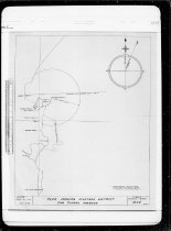
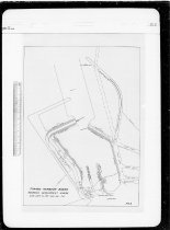
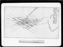
Timaru Harbour Board : plan showing pilotage district for Timaru Harbour - Timaru Harbour Board
Timaru Harbour Board, dated May 1958 Provides a plan of the circle of pilotage from 1 nautical mile from the end of the eastern extension. Includes locations of navigation beacons, trig points, and the under water rock shelf to the south of the harbour. Timaru Harbour Board Plan no.1048
Record Type: Archive
-
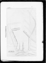
Timaru Harbour Board : plan showing position of leading beacons - Timaru Harbour Board
Plan showing position of Leading Beacons at Timaru Harbour, dated 1943. Provides a plan of the harbour with position of beacons and sectors covered marked out. Timaru Harbour Board plan no.810
Record Type: Archive

-
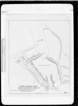
Timaru Harbour Board : plan showing proposed Groynes and anticipated line of reclamation - Timaru Harbour Board
Timaru Harbour Board : plan showing proposed Groynes and anticipated line of reclamation, signed and dated 19 October 1955 as approved by "Clerk of the Executive Council". Shows the location of four proposed short groynes stretching along the foreshore southward to Queen Street. Timaru Harbour Board Plan No. 938. Copy of M.D. 9909. See 2017/135.0169 for an undated original version of the plan (number 912).
Record Type: Archive

-
Timaru Harbour Board : plan showing proposed cargo sheds on southern approach of Caroline Bay - Timaru Harbour Board
Timaru Harbour Board plan showing proposed cargo sheds on southern approach of Caroline Bay, dated 9 July 1957. Timaru Harbour Board plan no.1013
Record Type: Archive

-
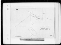
Timaru Harbour Board : plan showing proposed site for new building for Fishermen's Association - Timaru Harbour Board
Timaru Harbour Board plan showing the proposed site for new building for Fishermen's Association, dated 16 July 1956. Provides a site plan for the new building at the foot of the Fishermen's Wharf. Timaru Harbour Board Plan No. 982
Record Type: Archive
-
Timaru Harbour Board : plan to accompany Timaru Harbour Board Reclamation Bill 1894 - Timaru Harbour Board
Blueprint of the Timaru Harbour Board plan to accompany Timaru Harbour Board Reclamation Bill 1894, dated 18 July 1894. Provides a plan showing the boundary of endowments under the Timaru Harbour Board Act of 1888. Timaru Harbour Board plan 673. Copy of M.D. 1947
Record Type: Archive

-
Timaru Harbour Board : position of light-tower on new wharf [No.1 Wharf extension] - Timaru Harbour Board
Timaru Harbour Board plan for positioning a light-tower on the new No.1 Wharf extension, dated 3 March 1958. Provides a plan and elevation of the wharf area and simple elevations of the tower. Timaru Harbour Board plan no.1041
Record Type: Archive

-
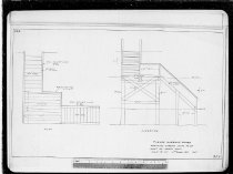
Timaru Harbour Board : private landing steps - MC Stilwell - Timaru Harbour Board
Undated plans for private landing steps for MC Stilwell on the North Mole at Timaru Harbour, circa 1950? Shows a simple plan of the steps location. Timaru Harbour Board Plan No. 889
Record Type: Archive

-
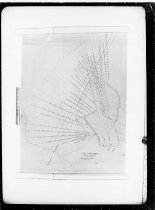
Timaru Harbour Board : proposed alterations to harbour navigation lights - Timaru Harbour Board
Timaru Harbour Board's proposed alterations to harbour navigation lights, dated 6 May 1948 Includes a plan of the coastline showing the arcs of the navigation lights, and text explaining the particulars of the assorted lights. Timaru Harbour Board Plan No. 842
Record Type: Archive

-
Timaru Harbour Board : proposed amenities building - Timaru Harbour Board
Timaru Harbour Board plan for a proposed amenities building, dated August 1962. Includes plan views, elevations, and a section. Signed as approved by B W Charman, Resident Engineer. Timaru Harbour Board Plan no.1171
Record Type: Archive

-
Timaru Harbour Board : proposed development scheme - Timaru Harbour Board
Timaru Harbour Board plan of the proposed development scheme, dated June 1960. Provides a plan of the area enclosed by the harbour, including the lengthening of No.2 Wharf and removal of half of No.3 Wharf after North mole berths have been completed. Dotted lines also indicate an additional mole within the Eastern Extension and from it's outer end. Timaru Harbour Board plan no.1112
Record Type: Archive
-
Timaru Harbour Board : proposed development scheme - Timaru Harbour Board
Plan of the Timaru Harbour Board proposed development scheme, dated June 1960. Provides a plan of the area enclosed by the harbour, with dotted lines indicating proposed new wharves inside the Eastern Extension. Timaru Harbour Board plan no.1110
Record Type: Archive
-
Timaru Harbour Board : proposed development scheme No.2 - Timaru Harbour Board
Timaru Harbour Board plan of the proposed development scheme No.2, dated July 1960. Provides a plan of the area enclosed by the harbour, including the lengthening of No.2 Wharf and removal of No.3 Wharf after North mole berths have been completed. Timaru Harbour Board plan no.1112A
Record Type: Archive
-
Timaru Harbour Board : proposed development scheme [approved plans] - Timaru Harbour Board
The approved Timaru Harbour Board development scheme, stage one plans (wharf construction), dated May and June 1961. Comprised of three plans, originally stapled together (staples removed) - plan no.1135, 1137 (sheet1 and 2). - Plan no.1135, dated May 1961, shows the overall scheme, with stage one marked in pink. - Plan no.1137 (sheet 1 & 2), dated June 1961, show a part plan of the decking and typical elevations of the piles - Plan no.1137...
Record Type: Archive

-
Timaru Harbour Board : proposed extension of No.3 Wharf Timaru Harbour - Timaru Harbour Board
A Timaru Harbour Board plan for a proposed extension of No.3 Wharf, signed by the Harbour Engineer FW Clarke and dated 12 October 1922. Provides a plan, cross section and several small detail drawings. Stamped "Approved in Council" and signed by F Thomson, Clerk of the Executive Council, dated 4 December 1922. Timaru Harbour Board plan 229. Copy of M.D. 5588
Record Type: Archive

-
Timaru Harbour Board : proposed extension of sections No.1 & 3 leased to New Zealand Shipping Co. Ltd - Timaru Harbour Board
Timaru Harbour Board : proposed extension of sections No.1 & 3 leased to New Zealand Shipping Co. Ltd, signed by Harbour Engineer BW Charman and dated 4 May 1953. Timaru Harbour Board Plan No. 892
Record Type: Archive

-
Timaru Harbour Board : proposed fishermans berths - Timaru Harbour Board
Undated plans for Timaru Harbour Board plans for proposed fishermen's berths off No.2 Wharf, circa 1988. Comprised of a single sheet showing the proposed berths perpendicular to the southern side of the inner end of No.2 Wharf. Provides a plan, typical section, and isometric view. Timaru Harbour Board Plan no.125
Record Type: Archive
-
Timaru Harbour Board : proposed landing steps to be built on North Mole - Timaru Harbour Board
The Timaru Harbour Board proposal plan for landing steps to be built on North Mole, dated 14 October 1955 A copy stamped as "Approved in Council", and signed off be Clerk of the Executive Council on 14 December 1955. Timaru Harbour Board Plan No. 959
Record Type: Archive
-
Timaru Harbour Board : proposed lay-out for No.3 Wharf and western North Mole - preliminary only - Timaru Harbour Board
Timaru Harbour Board proposed lay-out for No.3 Wharf and western North Mole, dated 1 March 1963. Comprised of a plan showing the reclamation of half the land between No.3 Wharf and the North Mole for a new cargo shed, and the proposed berthage available on the wharf and mole. also includes a cross section of the wharf. Timaru Harbour Board Plan no.1201
Record Type: Archive

-
Timaru Harbour Board : proposed lay-out of railway lines on new wharf [No.1 Wharf extension] - Timaru Harbour Board
Undated plans for the proposed lay-out of railway lines on new wharf [No.1 Wharf extension] for the Timaru Harbour Board, circa 1955 Signed "P.v.T" - Peter van Tilborg. The No.1 Wharf extension was completed in 1957. Timaru Harbour Board Plan No. 942
Record Type: Archive

-
Timaru Harbour Board : proposed new office and Store showing encroachment on railway land - Timaru Harbour Board
Proposal drawing for a new office for the Timaru Harbour Board Office on Ritchie Street (adjacent to the existing building), circa 1950? Provides a section plan showing the proposed new layout of the buildings, including area encroaching across the existing boundary with railway lands. Timaru Harbour Board Plan No. 913
Record Type: Archive

-
Timaru Harbour Board : proposed new quay, North Mole - Timaru Harbour Board
Timaru Harbour Board plan for a proposed new Quay for the North Mole, dated 12 January 1962 Provides sectional drawings for five proposals. Timaru Harbour Board Plan no.1172
Record Type: Archive

-
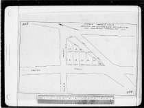
Timaru Harbour Board : proposed new section No. 67 [Hayman Street] - Timaru Harbour Board
Timaru Harbour Board plan for a proposed new section No. 67 on Hayman Street, dated 22 February 1956. Timaru Harbour Board Plan No. 970
Record Type: Archive
-
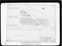
Timaru Harbour Board : proposed new sections along section 61-69 - Timaru Harbour Board
Plans for the proposed new sections for the Timaru Harbour Board along section 61-69 off Hayman and Fraser Streets, dated 6 December 1955. Signed "P.v.T." - Peter van Tilborg. Timaru Harbour Board Plan No. 968
Record Type: Archive
-
Timaru Harbour Board : proposed new wharf along Eastern Breakwater [no.1 Wharf extension] - Timaru Harbour Board
An undated plan for the Timaru Harbour Board's proposed new wharf along Eastern Breakwater, circa 1955. The plan was for the No.1 Wharf extension completed in 1957] Shoes the entire harbour, including the location of the proposed wharf. Timaru Harbour Board Plan No. 936
Record Type: Archive
-
Timaru Harbour Board : proposed new wharf and extension of inner harbour
Mr J P Maxwell's plan of a proposed new wharf and extension of inner harbour, published as a supplement to the Timaru Post. A subtitle/annotation notes that the plan was drawn to accompany a report of 14 December 1907. The plan shows the existing harbour, with proposed modifications in red. The modifications comprise of several parts: an addition of about 500 feet to the Eastern Extension; a 3000 foot western mole roughly parallel to the shore...
Record Type: Archive

-
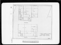
Timaru Harbour Board : proposed office - Timaru Harbour Board
Undated Timaru Harbour Board proposed office plans, circa 1950. Provides ground and first floor plans. Timaru Harbour Board Plan No. 881
Record Type: Archive
-
Timaru Harbour Board : proposed part of Caroline Bay to be transferred to T.C.C. - Timaru Harbour Board
Plan of the proposed part of Caroline Bay to be transferred to the Timaru City Council by the Timaru Harbour Board, dated 17 December 1958. Provides a plan of Caroline Bay showing the land to be transferred. Also shows the built facilities on the Bay, including the ball, aviary, tea rooms, stadium seats, dressing sheds, tennis courts, car parking, and scooter boats pool. Timaru Harbour Board plan no.1064
Record Type: Archive

-
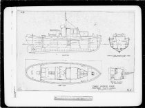
Timaru Harbour Board : proposed pilot launch - Timaru Harbour Board
Plans for a proposed pilot launch for the Timaru Harbour Board, signed by BW Charman and dated 6 August 1954 (sheet #914) and 4 March 1955 (#914a). Provides a plan, elevation, section, and proposed wheelhouse layout on one sheet (#914) and construction details of the timber construction on the other (#914a). The new pilot launch, named the Strathallan, came into operation at Timaru Harbour in 1958. Timaru Harbour Board Plan No. 914 & 914...
Record Type: Archive
-
Timaru Harbour Board : proposed sidings for Hayes Street extension - Timaru Harbour Board
Plan for the Timaru Harbour Board's proposed sidings for the Hayes Street extension, dated 3 August 1955. Shows the proposed siding locations, the location of a proposed overbridge, and labels several existing tenants including: Europa Oil NZ; British Petroleum; Steel & Tube Co, J McFarlane & Co; SC Electric Power Board; and Morrison Coal Co. Timaru Harbour Board Plan No. 946
Record Type: Archive

-
Timaru Harbour Board : proposed site for Timaru Fish Co. Ltd - Timaru Harbour Board
Timaru Harbour Board plans for the proposed site for the Timaru Fish Co. Ltd, dated March 1957. Provides a site plan for a proposed new building, office, platform, and jetty on the north side at the root of the No.3 Wharf. Comprised of a tracing, plus a paper copy signed off by the Minister of Marine on 15 May 1957 and stamped "Copy of M.D. 10192" Timaru Harbour Board plan no.1004
Record Type: Archive

-
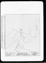
Timaru Harbour Board : proposed site of United Fisheries Ltd - Timaru Harbour Board
Timaru Harbour Board plan for the proposed site of United Fisheries Ltd, dated 6 June 1958. Provides a site plan for the site, near the foot of the Fisherman's Wharf. Timaru Harbour Board Plan no.1050
Record Type: Archive
-
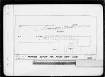
Timaru Harbour Board : proposed slipway for Power Boat Club - Timaru Harbour Board
Timaru Harbour Board plan for a proposed slipway for the Timaru Power Boat Club, dated 27 January 1959. Provides a plan and elevation of the proposed work, adjacent to No.2 Wharf. Timaru Harbour Board Plan no.1069
Record Type: Archive
-
Timaru Harbour Board : sections 29-34, 40-74 - Timaru Harbour Board
An undated cadastral plans for the Timaru Harbour Board showing sections 29-34, 40-74 along Fraser & Hayes Streets. Signed by the Harbour Board Engineer BW Charman and dated 5 March 1945. Bears subtext reading: "Compiled from plans No.165, 261, & 802." Timaru Harbour Board Plan No. 821
Record Type: Archive
-
Timaru Harbour Board : sections 76, 77, 78, 79 [between Hayes and Fraser Streets] - Timaru Harbour Board
Plans for Timaru Harbour Board sections 76, 77, 78, 79 [between Hayes and Fraser Streets], dated 23 October 1956. Includes the location of a proposed overbridge and goods shed. Timaru Harbour Board Plan No. 996
Record Type: Archive
-
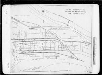
Timaru Harbour Board : sections and private sidings - Timaru Harbour Board
Timaru Harbour Board : sections and private sidings, circa 1953 1953 Shows sections on Ritchie, Dawson, Fraser, Hayes, and Hayman Streets. Includes labels showing existing tenants: Shell Oil, Atlantic Union Oil, Vacuum Oil, Caltex, GM McClatchie, Wright Stevenson & Co, Morrison, Midland Co-op, CFCA, PGG, Desmond Unwin, Dalgety, NMA & Co, Parr & Co, WA Piddington & Co, HJR Sommerville, Associated Motorists Petrol Co, British Petroleum, SC Power...
Record Type: Archive
-
Timaru Harbour Board : sections available for leasing - Timaru Harbour Board
A cadastral plan showing Timaru Harbour Board sections available for leasing. Signed and dated 7 March 1945 by the Board's Engineer BW Charman. Includes a key which indicates the original may have been (or intended to have been) coloured to indicate the sections available, but no such colour present. Timaru Harbour Board Plan No. 822
Record Type: Archive

-
Timaru Harbour Board : sections available for leasing - Timaru Harbour Board
An undated Timaru Harbour Board plan showing sections available for leasing, circa 1945? The plan shows the harbour and land adajcent to it to the south and west. The Harbour Boiard land to the south is colour coded to show availability of the land and sidings. Includes the HWOST for 1945. Timaru Harbour Board Plan No. 796
Record Type: Archive

-
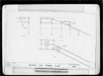
Timaru Harbour Board : slipway for Rowing Club - Timaru Harbour Board
Timaru Harbour Board plan for a slipway for the Timaru Rowing Club, dated 2 September 1957. Provides a coloured plan, section and elevation. Stamped: "Approved Pursuant to The Harbours Act 1950" and signed by LP Turner, Secretary for Marine, dated 23 October 1957 Timaru Harbour Board plan no.1026; Stamped copy of M.D.10283
Record Type: Archive
-
Timaru Harbour Board : soundings - Timaru Harbour Board
Timaru Harbour Board soundings, dated November 1958 to January 1959. Timaru Harbour Board Plan no.1067
Record Type: Archive

-
Timaru Harbour Board : soundings - Timaru Harbour Board
Timaru Harbour Board soundings for the harbour and approaches, dated 28 February 1958. Timaru Harbour Board Plan no.1063
Record Type: Archive

-
Timaru Harbour Board : soundings - Timaru Harbour Board
Timaru Harbour Board soundings of the harbour entrance and approaches, March to May 1962. Timaru Harbour Board Plan no.1163
Record Type: Archive
-
Timaru Harbour Board : soundings - Timaru Harbour Board
Timaru Harbour Board soundings for the harbour and approaches, dated July to August 1958. Timaru Harbour Board Plan no.1062
Record Type: Archive
-
Timaru Harbour Board : soundings October 1953 - Timaru Harbour Board
Timaru Harbour Board soundings, dated October 1953. Timaru Harbour Board Plan No. 901
Record Type: Archive
-
Timaru Harbour Board : soundings at No.1 Wharf before and after dredging - Timaru Harbour Board
Timaru Harbour Board : soundings at No.1 Wharf before and after dredging, dated 3 March 1943 Timaru Harbour Board Plan No. 794
Record Type: Archive