Archive Record
Images
Metadata
Title |
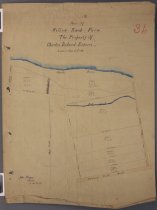
Plan of Willow Bank Farm. The property of Charles Boland Esquire |
Scope & Content |
"Plan of Willow Bank Farm. The property of Charles Boland Esquire", signed and dated by John Thompson as "August 23rd, 1915". A cadastral plan showing land parcels between Mill and Park (now Butler's) Roads south of the Opihi River. Gives measurement of parcel boundaries, their sizes and the location of a water race reserve and the Mill Stream as they cross the property. Scale 4 chains to an inch. |
Object Name |
Map |
Creator |
Thompson, John, Surveyor |
Date |
1915 |
People |
Boland, Charles |
Search Terms |
Opihi River, Canterbury Mill Stream, Timaru District Mill Road, Timaru District Park Road, Timaru District Butlers Road, Timaru District |
Subjects |
Farms Cartography |
Catalogue Number |
2010/049.06 |