Archive Record
Images
Metadata
Title |
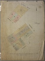
[Untitled plan of property parcels on Stafford Street, and on the corner of Stafford and Church Streets] |
Scope & Content |
Untitled plan of property parcels on Stafford Street, and on the corner of Stafford and Church Streets, nd (circa 1950??). The plan gives land parcel details for two areas - one from Stafford Street through to Le Crens Terrace and the other on the corner of Church and Stafford Streets. It provides parcel sizes, boundary lengths, adjacent roads, an indication of buildings and has names attributed to most parcels (see people and search terms). An annotation along the bottom edge reads "Distance subject to slight alterations upon completion of deposit plan". Note: copy #1 is coloured, while copy #2 has little/no colouration. Scale 20 links to an inch. Printed by the Timaru Herald. |
Object Name |
Map |
Creator |
Bridges, G A, Surveyor, Timaru |
Year Range from |
1920 |
Year Range to |
1970 |
People |
Strachan, H C Hurdley Wenham, A H McKenzie, J R Scott Orwin, R Simpson, J |
Search Terms |
Le Crens Terrace, Timaru Stafford Street, Timaru Church Street, Timaru Old Bank Hotel, Timaru Massey Harris & Co Ltd, Timaru |
Subjects |
Cartography |
Catalogue Number |
2010/049.29 |