Archive Record
Images
Metadata
Title |
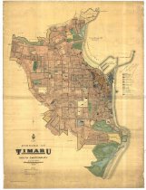
Borough of Timaru, South Canterbury |
Scope & Content |
Map of the Borough of Timaru, 1926, showing the area from Lagoon St to Luxmoore Rd and inland to Craigie St. Revised from a 1911 map. A colour coded key indicates the location of warehouses, shops, residential areas, etc. Also shows a harbour board tramline route and the bus routes within the borough. NB: The key has been crossed out with pencil and has "This notation superseded by that of Mr Mawson" written above it. Bears the crest of the Surveyor-General, W T Neil, above the title which appears in the bottom left corner. |
Object Name |
Map |
Creator |
Scmidt, H R |
Date |
1926 |
Medium |
Cloth backed paper |
Size |
1320(h) x 900(w) mm |
Area / Region |
Timaru Borough |
Search Terms |
Timaru Borough |
Subjects |
Cartography Maps |
Catalogue Number |
2001/235.001 |