Archive Record
Images
Metadata
Title |
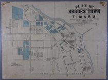
Plan of Rhodes' Town Timaru showing the property of Messrs Rhodes |
Scope & Content |
A colour printed map of Rhodes Town, circa 1885. Shows properties owned by W B Rhodes, R H Rhodes, and G Rhodes, as well as local railway lines, the harbour, streets, and notable buildings. Covers the area bordered by Wai-iti Road in the north, North Street in the south, and from the coast as far as William Street in the west. The original blue and red tints were used to designate let and unlet properties held by the Rhodes Brothers. The lower left corner gives the credit: "Compiled by McIntyre and Leur's Authorised Licensed Surveyors Christchurch". Scale 3 chains to 1 inch. |
Object Name |
MAP |
Creator |
McIntyre and Leur, surveyors, Christchurch |
Year Range from |
1875 |
Year Range to |
1890 |
Medium |
cloth-backed paper |
Size |
497(h) x 672(w) mm |
Scale |
1:2376 |
Area / Region |
Timaru |
Search Terms |
Rhodes' Town |
Subjects |
Cartography Maps |
Catalogue Number |
M0001 |