Archive Record
Images
Metadata
Title |
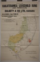
Plan of Hakataramea leasehold runs and freeholds : to be auctioned by Dalgety & Co. Ltd, Oamaru on Saturday, 22nd February at Wear St Hall, Oamaru |
Scope & Content |
A plan of Hakataramea leasehold runs and freeholds to be auctioned by Dalgety & Co. Ltd, Oamaru, on 22 February 1908. Provides a coloured plan of the area bounded by the Kirklistan Range and Waitangi Station in the east, the Hakataramea River in the West, and the Waitaki River in the south to the Hakataramea Downs Station in the north. The coloured areas were to be leased, while the smaller red areas were to be sold. Terms offered leases of 13 years and 10 months starting from 1 May 1908, with a half-year rent payable in advance. Freehold terms were 20% deposit and the remainder upon possession. The names of several blocks and station, along with block acreage, adjacent or current owners, and leasees are given. Other interesting features marked include several huts, one identified as Pig Valley hut, Kurow, the Hakataramea Railway Station, and a salmon hatchery on the Hakataramea River near the intersection with the Waitaki River. Surveyed by Fred W Freeman of Christchurch. |
Object Name |
Map |
Creator |
Freeman, Fred W, Surveyor, Christchurch |
Date |
[1908] |
Medium |
Paper |
Scale |
One mile to an inch |
Area / Region |
Hakataramea, Waimate District, N.Z. |
Publisher |
Christchurch Press Co Ltd |
Pub Place |
Christchurch, N.Z. |
People |
Hogg, Walter Hayes, A Sutton, J Milne, W Milne, T Nicholls, J O'Brien, (Mr) McCaw Ross, (Mr) Gemmel, J |
Search Terms |
Hakataramea, Waimate District Hakataramea Downs Station, Waimate District Hakataramea River, Waimate District New Zealand and Australian Land Company Pig Valley hut, Hakataramea, Waimate District Cattle Creek, Waimate District Mackay's Creek, Waimate District Hakataramea Station, Waimate District |
Subjects |
Farms Maps Auctions |
Catalogue Number |
2011/160.02 |