Search Term Record
Metadata
Name |
Fyfe, David, quarry, Timaru |
Details |
Located at the west end of the present (2018) Centennial Park, north of Otipua Creek and adjacent to Claremont Road. 1914, May - Opened 1916, 17 Jan - Closed 1928, Nov - [used?] 1929, Jan - opened 1931, 23 Mart - Closed 1932, 13 Jan - Lease terminated |
Related Records
-
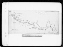
[David] Fyffe's Quarry, Timaru - Timaru Harbour Board
David Fyffe's Quarry, Otipua Creek, Timaru, dated 1912. Comprised of two plans of the location, one bearing the notation as "8 years from 27 January 1912". The quarry was located at the west end of the present (2018) Centennial Park, north of Otipua Creek. It was opened for use in 1914 and operated in a few short bursts until 1931. Timaru Harbour Board plan no. 628
Record Type: Archive
-
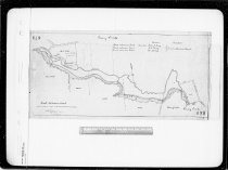
[Otipua Tramway and David Fyfe's Quarry along Otipua Creek, Timaru] - Timaru Harbour Board
Otipua Tramway and David Fyfe's Quarry along Otipua Creek, Timaru, nd (circa 1915). Provides a plan of the tramline passing along the present (2018) Centennial Park to David Fyfe's Quarry. Bears the notation "Areas and distances subject to alteration on completion of Survey Plan." Timaru Harbour Board plan no. 630
Record Type: Archive
-
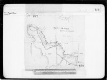
Plan of part RS 7024 for Quarry [David Fyfe's Quarry, Centennial Park, Timaru] - Timaru Harbour Board
Plan of part RS 7024 for Quarry [David Fyfe's Quarry, Centennial Park, Timaru], nd (circa 1914). Plan of part of the section that was David Fyfe's Quarry (opened in 1914). Timaru Harbour Board plan no. 620
Record Type: Archive
-
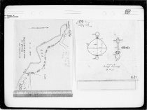
Quarry Lands [Otipua Creek, Timaru] - Timaru Harbour Board
Plan of Quarry Lands, Otipua Creek area, Timaru, nd (circa 1900). Covers the length of the present (2018) Centennial Park, from the foor of the zig-zag to Claremont Road, where the working face of David Fyfe's quarry is noted. The owners of the land occupied (J C King, Trustees of J King, and W Moody) are also indicated. Timaru Harbour Board plan no. 679
Record Type: Archive