Search Term Record
Metadata
Name |
Kirkliston Range, Canterbury |
Related Records
-
High country land management images
A series of prints and negatives collected by Ray Ward-Smith, property consultant, relating to high country land management in and around Mid and South Canterbury. The collection largely dates from between 1963 and 1989. Many of the images and collections relate to land conservation of high country and farming land managed by Lands & Survey Department. A separate index of the collection contents has been made. This series is numbered MP2 to...
Record Type: Photo

-
High country land management images
A series of slides collected by Ray Ward-Smith, property consultant, relating to high country land management in and around Mid and South Canterbury. The collection largely dates from between 1975 and 1985. Many of the images and collections relate to land conservation of high country and farming land managed by Lands & Survey Department. A separate index of the collection contents has been made. This series is numbered with an alpha-numeri...
Record Type: Photo
-
Kirkliston Land Management area
Twenty-two slides of the Kirkliston Land Management area, dated March 1995. Part of a larger donation of slides collected by Ray Ward-Smith, property consultant, relating to high country land management in and around Mid and South Canterbury.
Record Type: Photo
-
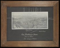
The Mackenzie Plains (from near Haldon) - Burnett Collection
A photographic print of the Mackenzie Plains (from near Haldon) after a drawing by E Norman, originally drawn circa 1850 to 1875.
Record Type: Photo