Search Term Record
Metadata
Name |
Opihi River, Canterbury |
Related Records
-
-
Hope Cole
A woman, possibly Hope Cole, pictured in her swimming costume at the Opihi River in 1935. Identified by details printed on the verso.
Record Type: Photo

-
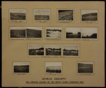
Levels County: soil erosion caused by the great flood - February 1945
A montage showing soil erosion caused by the "great flood" of February 1945 in Levels County. Fifteen prints mounted on a card backing providing labelled views: - "Hillside slips. J Agnew. Totara Valley" (two prints); - "Erosion of clay by running water. Rosewill Valley Road"; - "Hillside slips. W A Hartnett. Levels Valley"; - "Erosion of ploughed land. W J Black. Limestone Valley" (two prints); - Overflow from the Opuha River - Raincliff...
Record Type: Photo
-
Ophi {perhaps Opuha?] Gorge - Clayton Station Collection
Ophi [perhaps Opuha?] Gorge, pre 1890s? Bears the number "192" in the lower left corner. The entry with that number in the photographer's notebook (2011/028.630) identifies that image as "Opihi Gorge (most water[?])" and a margin note that appears to apply to this (and an adjacent group of listings) reads: "Very old i.e [prior[?] t[o?]] 1890".
Record Type: Photo
![Ophi {perhaps Opuha?] Gorge](https://s3.amazonaws.com/pastperfectonline/images/museum_58/208/thumbs/2011028688.jpg)
-
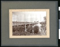
[Opihi Bridge]
The third Opihi bridge, the first major concrete bridge in South Canterbury, built in 1910. Further details are handwritten on the verso: "Opihi bridge in which Milburn Cement was used entirely, F W Marchant engineer, Emil Hall & Sons contractors. Chas King agent for the Milburn Coy & photo ..." The bridge was 961 feet long with a traffic width of 20ft over 23 spans. A description of a test of the bridge appeared in the Timaru Herald on...
Record Type: Photo
-
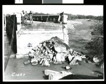
[Opihi Bridge and approach flood damge, 1951]
A series of five photographs of the flood damage to the Opihi Bridge and approach taken in 1951 prior to repair work being undertaken. Each photograph is numbered (C1457 to C1459, C1461, and C1464 respectively) and stamped on the verso with "T Barker WD [Works Department] ChCh, 24 Apr 1951" Originally stored in a brown envelope bearing the title "No.3 : Christchurch-Timaru S.H. 58 Opihi Bridge bridge approach repairs 1952."
Record Type: Photo
-
Photograph album : C R Anderson
An undated black and blue vinyl album of assorted scenes produced by C R Anderson, featuring numerous Mackenzie District scenes, that appears to date from the mid twentieth century. Multiple prints are present on each page, with each page featuring a main title and separate titles for each image as follows: - #03: Lake Ohau ("place of the winds") MacKenzie Country - A storm-worn black birch frames a view of the Lake; View up the lake from The...
Record Type: Photo

-
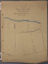
Plan of Willow Bank Farm. The property of Charles Boland Esquire
"Plan of Willow Bank Farm. The property of Charles Boland Esquire", signed and dated by John Thompson as "August 23rd, 1915". A cadastral plan showing land parcels between Mill and Park (now Butler's) Roads south of the Opihi River. Gives measurement of parcel boundaries, their sizes and the location of a water race reserve and the Mill Stream as they cross the property. Scale 4 chains to an inch.
Record Type: Archive
-
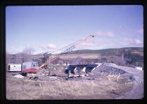
[Raincliff Bridge construction]
Construction iof the Raincliff Bridge over the Opihi River in July 1966. Bears identifying notes on the slide mount.
Record Type: Photo
-
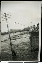
Repairing telephone lines, Opihi road bridge
Repairing damaged telephone lines across a flood-damaged Opihi River, believed to be on the on the approach to Temuka, after the waters began to receded from flooding in 1951. The image shows linesmen on the end of the bridge, adjacent to a washed-away span, with a long pole. Presumably they were looking to hook and retrieve or deliver loosely hung lines from the damaged telephone pole located a few metres away from the damaged bridge.
Record Type: Photo
-
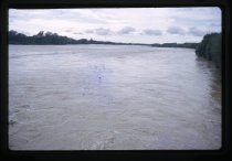
[Rivers in Flood]
Opihi and Tengawai rivers in flood. January 1965. Bears identifying notes on the slide mount along with the photographers initials.
Record Type: Photo
-
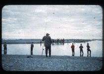
Salmon Fishing, Opihi
A colour slide showing anglers identified as "Salmon Fishing, Opihi", pictured either side of the river mouth circa 1960.
Record Type: Photo
-
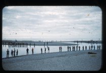
Salmon Fishing, Opihi
A colour slide showing anglers identified as "Salmon Fishing, Opihi", pictured either side of the river mouth circa 1960.
Record Type: Photo
-
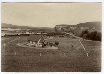
[St David's Anglican Church, Raincliff]
St David's Anglican Church, Raincliff, circa 1907. Viewed from a nearby height, looking down at church with several people and two horse-drawn carriages drawn up outside. On the verso in pencil is written "? date 10-2-1907". The church was opened on 10 March 1907. In the distant background the confluence of the Opihi and Opuha Rivers is visible.
Record Type: Photo
-
Steve Dore and his 35lb salmon caught at the Opihi River - Timaru Herald Photographs, Personalities Collection
Steve Dore posed with a 35 pound (15.9 kg) salmon he caught at the Opihi River, dated 18 January 1995. The article that the image was used for appeared in the Timati Herald on 19 January 1995, naming Steve Dore in the text, but mis-identifying him as Peter in the image caption.
Record Type: Photo

-
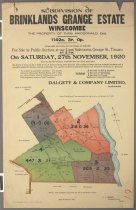
Subdivision of Brinklands Grange Estate, Winscombe, the property of Thos. MacDonald, Esq.
"Subdivision of Brinklands Grange Estate, Winscombe, the property of Thos. MacDonald, Esq." Offered for sale at Dalgety & Co's auction rooms in Timaru on 27 November 1920. A cadastral plan showing land parcels between the Fairlie-Timaru Highway and the Opihi River, north of the present Opihi Gorge Road (marked but not labelled). Shows the four parcels to be sold, noting fencing, crop of pasture types present, ditches and houses plus other buil...
Record Type: Archive
-
Swimming, Opihi River
Two woman, identified as "Pat & Yola", pictured their swimming costume at the Opihi River in February 1941. Identified by details printed on the verso.
Record Type: Photo

-
The camp[.] Protective works[.] Contractors WJ Black & Son
An undated photograph of "The camp[.] Protective works[.] Contractors WJ Black & Son", circa 1930. Presumably the contractors were working on flood control works, such as flood banks and/or channels. Depicts men and women posed around numerous carts and drays (at least four bearing the name of the contractor, plus an early horse-drawn grader, and a covered wagon belonging to "J King, General Carrier" (in the centre background) at the camp site...
Record Type: Photo
![The camp[.] Protective works[.] Contractors WJ Black & Son](https://s3.amazonaws.com/pastperfectonline/images/museum_58/175/thumbs/201311812.jpg)
-
Timaru City Council Municipal Electricity Department : proposed 11KV & control U/G [underground] cabling, Saleyards Bridge, Opihi River, Pleasant Point
A Timaru City Council Municipal Electricity Department (MED) plan of proposed 11KV and control underground cabling across the Saleyards Bridge over the Opihi River, Pleasant Point. Drawn on 8 September 1976, with revisions to 22 December 1977. The sheet is drawn to a scale of 1:500, showing underground cable connections and building outlines at the school. The title, date, drawing, and revision details, plus the MED's plan number (1343) app...
Record Type: Archive